Introduction
The Henderson Interchange, which connects highways I-515, I-11, I-215, and Lake Mead Parkway, was constructed between 2004-2006 when Clark County, NV had a population of approximately 1.5 million residents. With the County’s population now at more than 2.2 million, the interchange is in urgent need of improvement to accommodate present and future traffic demands. The Nevada Department of Transportation, the City of Henderson, and engineering consultant C A Group are now engaged in the NEPA process for the selected “build alternative” to replace the existing interchange.
Publish, Don’t Render – A Do-It-Yourself Approach to Affordable Visual Assets
C A Group had worked with RDV Systems in earlier stages of the project and turned to RDV once again to help prepare visualization content for a virtual public meeting website. NDOT and C A Group needed an unusually high amount of visualization content.
As C A Group president Jim Caviola described, “This interchange not only impacts highway-to-highway connections, but access to several important local arterials. In earlier pre-pandemic public outreach efforts we learned that what every person wanted to see was how they would get from their own particular Point A to Point B. For our upcoming virtual Henderson Interchange Open House website, we wanted to set up drive-through videos of every possible driving route”.

RDV applied its 123BIM applications to turn the project’s Microstation and Open Roads design files into a detailed, geometrically accurate 3D virtual model of the interchange itself and of the connecting highways for several miles in each direction. RDV then set to work helping C A Group create the video content they needed. As Kevin Stewart, RDV’s Director of Operations describes –
“This project exemplifies the power and economy of RDV’s ‘Publish, Don’t Render’ philosophy. NDOT wanted videos for 17 separate driving routes totaling over 65 miles of driving, as well as several flyover clips. That added up to over one hour of video footage. Developing that much content with traditional visualization methods on a cost-per-video-minute basis would have run into the hundreds of thousands of dollars. With 123BIM it was easy to use the published 3D model to create as many drive-throughs and fly-overs as they needed, all within a couple of days”.

Kevin Stewart
Director of Operations
RDV Systems Inc.
The virtual public meeting website went live on July 6, and included 27 videos exported from the 3D model.

Over 65 Miles
17 separate driving routes simulated
totaling over 65 miles of driving

Big Savings
$100,000s savings from traditional
visualization video production

27 Videos
More than 1-hour of footage was
exported from the 3D model
Design Validation with 3D Modeling and Safety Analysis
Like many RDV clients whose initial focus was on visualization for public outreach, C A Group quickly discovered the value of the 123BIM model for evaluating details of their proposed design. As C A Group’s senior project manager Jim Mischler stated –

James Mischler
Senior Project Manager
C A Group
“It makes a huge difference when you can see all of the different design elements put together in an accurate and realistic 3D environment. 123BIM let us explore the entire project interactively and catch many design shortcomings and flaws early in the process. At the crossover lanes we had designed some S-curves according to AASHTO standards, but when we were able to see them from a driver’s perspective it became clear that we could make some improvements for better and safer operation. We also discovered and resolved issues with overhead signs that had looked fine on the 2D signing plan, but had problems that became obvious in the 3D environment. There were many examples of this kind of early detection and resolution”.

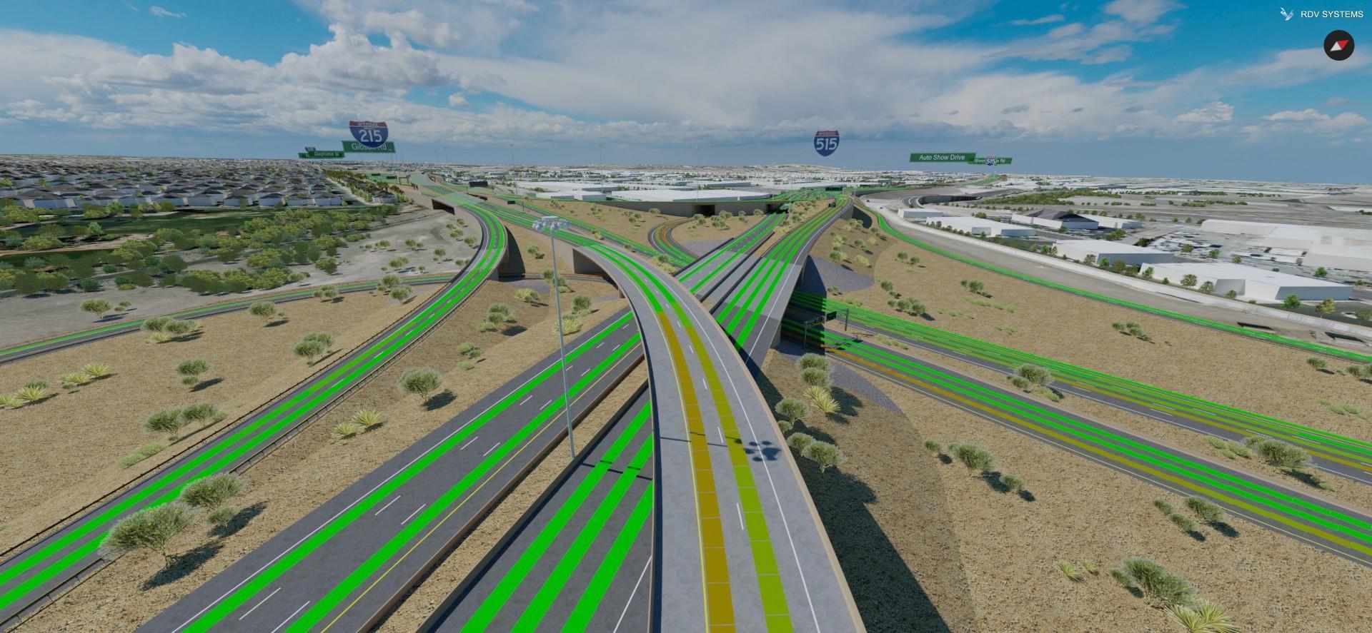
Henderson Interchange – Overview
C A Group also opted to engage RDV to help validate certain aspects of the design by running roadway safety simulations with its Roadway Safety Audit 3D (RSA 3D) application. As RDV’s Road Safety Industry Manager Larry Mohr describes –

Larry Mohr
Business Development Manager
RDV Systems Inc.
“RSA 3D applies AASHTO sight distance methodologies in a new way. Instead of separated 2D straight-edge analysis of vertical and horizontal centerline curves, RSA 3D steps down each travel lane and tests if the driver can see that two-foot object at the required sight distance for the design speed, taking the whole 3D environment into account. If not, it iterates until it determines the maximum safe driving speed”.


Color-coded illustration showing the maximum safe driving speed at each location
RDV used the 123BIM model to run stopping sight simulations on all travel lanes for the entire lengths of the four highways running through the interchange. According to Mr. Mischler –
“The proposed interchange includes an innovative crossover of travel lanes with S-curves, and it features a curved flyover ramp connecting I-215 and I-515. Also NDOT had recently increased the heights of their standard side barriers. With these complex geometric configurations, we wanted to be sure that we were maintaining adequate stopping sight distances for our target design speeds. We had seen what RDV had done with RSA 3D on another interchange project and thought it was ideal for our situation.”
The results were published in the form of a color-coded and annotated CAD drawing that showed the maximum safe driving speed at every location throughout the project. In addition, RSA 3D provided a detailed interactive report that let the project engineers see each location in the model to help determine the causes of sight distance deficiencies.


Top: Henderson Interchange – Max speed per NDOT standards
Bottom: I-215 Road Section with lower speeds due to sight distance deficiencies
According to RDV’s CEO Natan Elsberg –
“A sight distance issue might be caused by a number of factors – horizontal curvature, vertical curvature, superelevation, roadside vegetation, obstructing structures, or some combination of these. The RSA 3D interactive report lets the engineers see what the driver would see to help identify causes and then determine the best way to mitigate the issues.
Traditional road safety practice can’t do this, it can only be done using a 3D model”.

Natan Elsberg
CEO and Founder
RDV Systems Inc.
The analysis revealed some areas that were deficient, and C A Group was able to make adjustments and corrections to the design geometry to bring these areas into compliance. For example, the investigation of one deficient area showed an error in the way superelevation on a curve had been applied, causing two sections of roadway to join incorrectly.

Error in Superelevation on a Curve
“This just goes to show another hidden benefit of the digital modeling process – if you can’t build it in the model, it shows us that a contractor couldn’t build it in the field. Better to learn these issues now than later when they can be quite costly.”
– Jim Mischler
RDV couldn’t agree more!
Visualization as a Living Document
RDV’s involvement in the Henderson Interchange project goes back several years, and demonstrates the value of maintaining the 123BIM model as a “living document”, starting at the earliest stages of a project. The key to RDV’s approach is to focus on publishing a geometrically accurate 3D model of the proposed design, rather than rendering videos. That model can be explored interactively, is easily updated as the project progresses, and lets the project team create images, videos, and virtual tours quickly and inexpensively.

About RDV Systems
RDV Systems has been delivering innovative visualization products since 2005. Our mission is to provide tools for project visualization and road safety audits that dramatically expand the capabilities of engineers, designers, and safety officials, and allow for new ways to cooperate and communicate effectively at a cost feasible for projects of any size. Consultants and public agencies around the world rely on RDV software products and services to visualize, analyze, and communicate their designs.
